top of page


Switzerland Hikes
Browse this page for some very spectacular hikes in Switzerland, with General Descriptions, Trip Tips and Hiking Tips.
Use the drop down sub menu under Hiking for other country locations.
ENJOY!

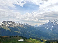


Bachalpsee
Grindelwald, Switzerland
This is a great hike that goes up to the Bachalpsee (altitude 2,266m) lake starting from the town of Grindelwald. The elevation gain is 1,274 metres - a strenuous climb from the town up to the First mountain.
This hike is also called the flower trail because along the way there are informational panels about the alpine flowers in this area such as gentian, silver thistle, chamomile and cotton grass.
At the top you are treated with awesome panoramic views of the many famous peaks in Jungfrau Region including the Eiger and Jungfrau Joch.
Bachalpsee itself is a lake set near the top of these mountains - frozen in winter and collecting the snow melt in Spring and feeds the several waterfalls in the area. On your hike up you will pass the Bachlagerwasserfall.
If you are not super excited about the climb, you could take the First Gondola up to First Peak. The out and back hike from there is about 6.5km with a few gentle to moderate gradients.
Another spectacular mountain hike in Switzerland!
Instagram REEL:
https://www.instagram.com/reel/C7_jqWESkbU/


Trip Tips
-
Best season to do this hike is from June to through November. In the Winter and most of Spring, expect snow and ice on this trail, and some sections may not be passable due to possible snow / ice slide or avalanches.
-
Grindelwald is a popular Ski destination. In the Summer the area is popular with tourists, hikers and climbers. It is worthwhile to stay several nights in Grindelwald as there are several awesome hikes in the area.
-
It is quite easy to travel by train within Switzerland that gets you to most major centres. For greater independence, time saving and flexibility, consider getting a rental car as we did.
-
The First Gondola is very popular for tourists visiting the many attractions at the top besides hiking, so we recommend and early start to beat the crowds.
-
Many petrol refuelling stations in Europe are not attended by cashiers. Often your foreign credit card and PIN do not work at the pumps. So have the right amount of cash as the fuel is prepaid and change is not provided, so you need to have some idea about your tank size and be a a bit of a math wizard.
Hiking Tips
-
We were there in early June 2024. It was not quite peak tourist season, so it was not too busy at the top.
-
However, the second half of the trail to Bachalpsee was still patchy with ice and snow and there was still significant snow drift above the trail. So proceed with caution and do not go alone.
-
Do look out for any signs that the trail may still be closed depending on trail conditions if you go in late Spring or early Summer.
-
The lake itself was still mostly frozen as can be seen in the photo but it offers a great winter like hike among the snow and ice.
-
Along the trail, we spotted foxes and toads enjoying the Spring thaw.
-
Best restaurant in Grindelwald - Barrys Restaurant Bar & Lounge (reservations!), followed by the restaurant in the Spinne Hotel.
Mannlichen - Eiger Glacier
Wengen / Grindelwald, Switzerland
This is a fantastic trail for getting a in-person aerial perspective of the entire Jungfrau mountain ranges from a 'Royal" lookout perched in the middle of all the surrounding peaks. The best times to visit this trail are June through September.
This beautiful hike leads to the Eigergletscher (2320m) railway station at the edge of the Eigergletscher glacier. Great views of the Bernese Alps and their glaciers in a very alpine and popular region.
The trail head can be reached from Wengen with the Wengen – Mannlichen cable car or from Grindelwald with the Grindelwald – Mannlichen gondola. The hike leads over alpine meadows down to the Kleine Scheidegg (2061m), where hikers can enjoy a beautiful view of the Jungfrau massif.


Trip Tips
-
Check cable car opening dates to plan you trip. Depending on trail safety conditions, the Cable car from Grindelwald to Mannlichen opens only towards the end part of May for the Summer hiking season.
-
Our recommendation is to stay in Grindelwald where you have easy access to Jungfrau Joch, Grindelwald First (from the the hike to Bachalpsee featured here), and you have more activities, shops and restaurants than at Wengen.
-
When you stay at a hotel in Grindelwald you also get to ride the local buses for free getting you to the train station or to the terminal where the cable cars leave for Mannlichen and JungfrauJoch.
-
Many petrol refuelling stations in Europe are not attended by cashiers. Often your foreign credit card and PIN do not work at the pumps. So have the right amount of cash as the fuel is prepaid and change is not provided, so you need to have some idea about your tank size and be a a bit of a math wizard.
Hiking Tips
-
We were there in early June 2024. It was not quite peak tourist season, so it was not too busy at the top and there was still snow / ice on the ground but the walking trails were mostly cleared.
-
Do look out for any signs that the trail may still be closed depending on trail conditions if you go in late Spring or early Summer.
-
Part of this trail is also known as the Mannlichen Royal Walk. The last bit of climb up to the lookout is a steep rope assisted climb. This climb is totally worthwhile for a 360 panorama of the region - amazing views South-East to the narrow but beautiful Lauterbrunnen Valley, North to Interlaken, South to the peaks of Eiger and Jungfrau and across East to Grindelwald First.
-
Best restaurant in Grindelwald - Barrys Restaurant Bar & Lounge (reservations!), followed by the restaurant in the Spinne Hotel.
Oeschinensee
Kandersteg, Switzerland
Oeschinensee (Oeschinen Lake) is located near Kandersteg in the Bernese Oberland at 1,578 metres in altitude with a surface area of 1,148 Square Metres. Well know for its emerald waters and beautiful snow capped mountain backdrop, it si popular for both tourists and hikers.
The loop hike up from the Oeschinen Valley Station is strenuous and has an elevation gain of 557 metres, and the total hike distance is about 9 kilometres.
For an easier hike of just the loop around the lake without most of the climb, you could take the Oeschinensee Gondola.
The Gondola and Lake front is very popular with tourists, but the loop hike has much less traffic, hence offers quieter time with great views from higher elevations above the lake.

Trip Tips
-
When planning your trip check trail conditions as the upper portions of the loop trail may still be closed in late Spring / early Summer due to risks of Avalanches.
-
The drive from Grindelwald or Interlaken is just over 1 hour. So you could make it a day trip from either of these two locations.
-
On the way to Oeschinensee, it is easy to make a short stop at Blausee (Blue Lake) which really is a beautiful green. The lake is smallish compared to Oeschinensee and the entry fee to the lake may be a deterrent.
-
Many petrol refuelling stations in Europe are not attended by cashiers. Often your foreign credit card and PIN do not work at the pumps. So have the right amount of cash as the fuel is prepaid and change is not provided, so you need to have some idea about your tank size and be a a bit of a math wizard.
Hiking Tips
-
For avid hikers, the 9-kilometre, 557-metre elevation gain loop hike would make for a rewarding day with the beautiful vistas above the lake. If you are short of time, then take the gondola up and down and still do the loop around the lake.
-
Do look out for any signs that the trail may still be closed depending on trail conditions if you go in late Spring or early Summer.
Aareschluct
(Aare Gorge)
Meiringen, Switzerland
Aareschluct (Aare Gorge) is a beautiful 24-kilometre out and back walk on elevated board walk / caves over a lovely gorge.
Located at Meringen, it is only 47 minutes' drive from Grindelwald, a little less from Interlaken.
The walk is mostly flat except for a set of steps at the Eastern end leading up to the exit point where you could catch a train back to the car park where you started. Cost of the return train ride is included in your entry ticket. However, we recommend that instead of taking the train back, just turn around and walk back where you came from to get a different viewing perspective in the reverse directions.
This walk is a very popular for tourists and hikers. The best times to visit this trail are April through October.
All information about the Aare Gorge is available here: https://aareschlucht.ch/

Trip Tips
-
When planning your trip check if the Aareschluct is open as it could be closed for maintenance or other reasons
-
As this is only a short walk, make full use of your day in this area by also visiting the very impressive Reichenbach Falls near Schattenhalb. Legend has it that it was at this fateful falls that Sherlock Holmes had a fight to the death with Professor Moriarty.
-
All information about the Aare Gorge is available here: https://aareschlucht.ch/
-
Many petrol refuelling stations in Europe are not attended by cashiers. Often your foreign credit card and PIN do not work at the pumps. So have the right amount of cash as the fuel is prepaid and change is not provided, so you need to have some idea about your tank size and be a a bit of a math wizard.
Hiking Tips
-
This is an easy but beautiful walk that takes less than 2 hours out and back.
-
There are also a couple of waterfalls coming from the gorge faces down into the river below.
-
We recommend that instead of taking the train back, just turn around and walk back where you came from to get a different viewing perspective in the reverse directions.
-
Plenty of beautiful photo opportunities.
Engstligen Falls
Adelboden, Switzerland
Located in Adelboden, Engstligen Falls is the second tallest waterfall in Switzerland at 600 metres vertical drop.
These falls are a natural spectacle and have been under cantonal nature protection since 1948.
The falls is so tall they can be seen from a distance even from the opposite peaks and you could hike up real close to the main falls which is super impressive with its splashing cascades and the refreshing mist that it generates.
You can hike to the falls on a 2.5-kilometre loop starting from the Unter dem Birg car park. It leads through a lovely forest until you come up close to the waterfalls.
For a longer hike, you could also walk from the town of Adelboden which is 13 kilometres with an elevation gain of 400 metres.


Trip Tips
-
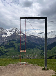
If you have time, Adelboden is a beautiful town to stay a few days in, so you can easily do the full hike to the falls, and also visit the Risenschaukel (Giant Swing) on the back of the town.
-
Alternatively, it is also an easy day trip from Interlaken or Grindelwald, with a drive of less than an hour.
-
Finding parking is not easy on Dorfstrasse in Adelboden to grab lunch, shop or to take the cable car to Riesenschaukel, but you can easily find a spot in the Parkhaus Zentrum on Zelgstrasse behind the Adler Hotel. This is paid parking.
-
Many petrol refuelling stations in Europe are not attended by cashiers. Often your foreign credit card and PIN do not work at the pumps. So have the right amount of cash as the fuel is prepaid and change is not provided, so you need to have some idea about your tank size and be a a bit of a math wizard.
Hiking Tips
-
We only had time in our Swiss trip to make a day trip to Adelboden, hencce we only did the short loop from Unter Dem Birg (cable car station), so that we could get up to Riesenschaukel the same afternoon.
-
The short hike through the woods was extremely pleasant. Coming up close to this majestic falls, you would want to spend time to soak it all in. The rapid flowing stream under the falls is also a mesmerizing experience.
Tschentenalp
Adelboden, Switzerland
Located in Adelboden, this 8.2-km loop trail is a challenging route with a 592-metre elevation gain.
The trail starts in Adelboden in the canton of Bern in the Bernese Oberland. In Winter, this is a great ski area. The trail leads up to the Tschentenalp.
At the top, you have a fantastic view across the valley to the 600-metre tall Engstligen Falls in the distance. Also at the top is the Instagram-popular Riesenschaukel (Giant Swing). Hence this alp is very popular with tourist and hikers.

Trip Tips
-
If you have time, Adelboden is a beautiful town to stay a few days in, so you can easily do the full hike to the falls, and also the Tschentenalp loop hike and visit the Risenschaukel (Giant Swing) on the back of the town.
-
Alternatively, it is also an easy day trip from Interlaken or Grindelwald, with a drive of less than an hour.
-
If you are on a day trip and do not have time to do the full loop hike, there is a cable car that takes you from the town up to the top.
-
Finding parking is not easy on Dorfstrasse in Adelboden to grab lunch, shop or to take the cable car to Riesenschaukel, but you can easily find a spot in the Parkhaus Zentrum on Zelgstrasse behind the Adler Hotel. This is paid parking.
-
Many petrol refuelling stations in Europe are not attended by cashiers. Often your foreign credit card and PIN do not work at the pumps. So have the right amount of cash as the fuel is prepaid and change is not provided, so you need to have some idea about your tank size and be a a bit of a math wizard.
Hiking Tips
-
Enjoy this beautiful hike and don't miss the chance to get some awesome photos at the Riesenschaukel.
-
When in town after a hike, strongly recommend to chill or have a meal in the restaurant of the Adler Adelboden. Grab a table at the big windows and enjoy the glorious views.
-
https://www.alltrails.com/trail/switzerland/bern/adelboden-tschentenalp
Lac de Tseuzier
Crans Montana, Switzerland
This is a beautiful 5-km loop trail high up near the tops of the mountain ranges near Crans-Montana at an altitude of 1,900 metres.
The best times to visit this trail are May through October.
The dam can be reached by car on the Route du Rawill via a long series of narrow and steepish switch back.
On the way, the Gîte de Lourantze is a small hut offering accommodation and catering. The spring with the waterfall at the lake's back end is worth a visit. The Restaurant du Barrage offers seasonal cuisine at the foot of the dam

Trip Tips
-
If you are driving from the German-Speaking part of Switzerland to Crans Montana, be prepared to have to put your vehicle onto a narrow train at Kanderstag, going through the Loetsberg Tunnel to get Goppenstein on the French side of Switzerland.
-
As the crow flies, the dam is only 5 kilometres horizontal distance from Crans Montana but the actual drive is 25 kilometres with a climb of 400 metres on very narrow switchbacks. There are also a couple of single lane tunnels so you need be conscious of vehicles coming the other way and someone has to reverse and back up..
-
Be sure to have at least half a tank of fuel when you start driving up this mountain - the climb empties your tank real quick!
-
Many petrol refuelling stations in Europe are not attended by cashiers. Often your foreign credit card and PIN do not work at the pumps. So have the right amount of cash as the fuel is prepaid and change is not provided, so you need to have some idea about your tank size and be a a bit of a math wizard.
Hiking Tips
-
The hike around the lake is only 5 kilometres and an elevation gain of 156 metres. However, there are some sections where the trail is quite eroded, so exercise caution and it is not advisable to cross these parts alone.
-
The view from the dam across the lake framed by magnificent white peaks is gorgeous. Enjoy the views also on the other side of the dam looking down to the valley and mountains on the far side.
-
The Restaurant du Barrage de Tseuzier at the dam was not open when we were there in early June.
-
https://www.alltrails.com/trail/switzerland/valais/tour-lac-tseuzier
bottom of page