


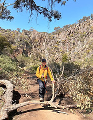


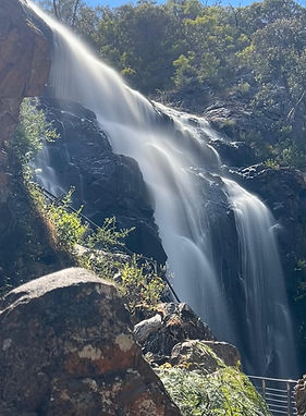
George Bass Coast
Kilcunda, Victoria
The George Bass Coastal Walk is my favourite coastal hike in Victoria. Being just 1.5-hours drive from the Eastern suburbs of Melbourne, it is my go-to walk whenever I need to be on the coast. The cliff top views are stunning, the beaches beautiful and the rock pools amazing.
There is abundant bird life living on this coastal bluff, seen mostly in the early morning or in the evenings. But very likely, if you look upwards you are likely to see raptors circling for their next meal.
In the winter, migrating whales could be spotted off the coast - bring your binoculars or zoom lenses!
I must have done this walk a dozen times in the last 6 years but each time I come back, I get the same exhilarating feeling of being totally immersed in the wonders of the beautiful natural landscapes and the wild life that surrounds it.
Instagram REEL:


Trip Tips
-
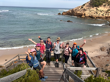
The George Bass Coastal Walk is on a stunning cliff top just a few kilometres East of Phillip Island.
-
If you are visiting Phillip Island for the first time, you could spend a week and still have plenty to do.
-
Iconic hikes in and around the island include Pyramid Rock to Berrys Beach; Cape Woolamai loop, George Bass Coastal Walk; Churchill Island National Park; and The Nobbies Board Walk.
-
Close up wildlife experiences include the Koala Sanctuary, Seal Cruises, Whale Cruises, and Fairy Penguin Parade.
-
The town centre of Cowes is a hive of restaurants, bars and retail activities. The Cowes Market that takes place one Sunday a month brings the town to life with food and craft stands and live music!
-
Be sure to browse in the Phillip Island Collectable Antiques stores to find amusing stuff from the ages.
Hiking Tips
-
The end to end walk from Kilcunda to Punch Bowl is about 7.5 kilometres (or 15 kilometres out and back).
-
For a shorter out and back walk, we would recommend to start at Kilcunda and walk to Half Moon Bay Lookout before turning around. This return walk is about 12 kilometres.
-
Do bring a pair of good binoculars or a good camera with zoom lenses to capture the raptors soaring above you, or migrating whales off the coast in the winter.
-
Allow time to explore the rock pools at Half Moon Bay. They are very inviting for stepping in, and you may find interesting marine life in the pools.
-
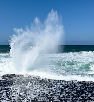
The surf off the coast is dangerous, and people have been washed off by rouge waves pounding the rocky coast.
-
The Kilcunda General Store is a cool spot for a coffee pre or post hike!
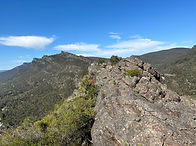
Cape Woolamai Loop
Phillip Island, Victoria
Next to the George Bass Coastal Walk, the hike at Cape Woolamai ranks up top for amazing cliff top hikes in Victoria. I must have done this hike at least a dozen times and still get excited each time I go there again!
Besides wallabies and birdlife (and snakes!), Cape Woolamai is home to nearly a million migratory shore birds - the Short Tailed Shearwaters. Every September, they fly 16,000 kilometres from islands off Alaska to come here to breed and stay through the Northern Winter.
This hike has lots of variety to offer - two walks on beautiful contrasting beaches - Woolamai Surf Beach with its strong surf hosts frequent surfing competitions, whereas the beach on the other side of the cape - Cleeland Bight is calm and serene!
The gentle climb up the cape takes you to the stunning Pinnacles, and then on to the top where stands the Cape Woolamai Beacon. Coming dow the hill, you veer right to get to Cleeland Bight before looping back on a sand filled trail back to Woolamai Surf Beach.
Instagram REEL:

Trip Tips
-
Cape Woolamai is the highest point on Phillip Island.
-
If you are visiting Phillip Island for the first time, you could spend a week and still have plenty to do.
-
Iconic hikes in and around the island include Pyramid Rock to Berrys Beach; Cape Woolamai loop, George Bass Coastal Walk; Churchill Island National Park; and The Nobbies Board Walk.
-
Close up wildlife experiences include the Koala Sanctuary, Seal Cruises, Whale Cruises, and Fairy Penguin Parade.
-
The town centre of Cowes is a hive of restaurants, bars and retail activities. The Cowes Market that takes place one Sunday a month brings the town to life with food and craft stands and live music!
-
Be sure to browse in the Phillip Island Collectable Antiques stores to find amusing stuff from the ages.
-
On a clear evening, be sure to catch the stunning sunset from Cape Woolamai and then watch the constellations appear in the dark skies.
Hiking Tips
-
The loop hike around Cape Woolamai starting at Woolamai Surf Beach, up to the Pinnacles, the the lighthouse and returning on the beach on Cleeland Bight is about 8 kilometres.
-
Note to check tide times when picking a date and time for your hike. The beach at Cleeland bight is practically in knee deep water during high tide.
-
In the warmer months, you are likely to find families board surfing down the steep sand hills at Norman Hill down into Cleeland Bight. It looks so fun, you would be tempted to have a go too!
-
The surf off the coast is dangerous, and people have been washed off by rouge waves pounding the rocky coast.
-
The Wooli Tavern situated at the big round-about on the drive into the cape is a cool spot for a coffee pre or post hike!
Lerderderg Gorge Loop
Coimadai, Victoria
When I first started out as a regular bush hiker some years ago, the hiking the Lerderderg Gorge Loop was like a daunting unattainable goal given its reputation of a severely steep and rocky climb of more than 400m in a short span of 1 kilometre horizontal distance. That is a nearly 45-degree of rock scrambling incline!
With many weeks of regular hiking and a mental resolve of putting one foot in front of the other, I finally did it in 2022 with someone more than a decade younger and actually keeping up!
Since then, I have taken different groups of friend back to do the loop 3 more times, each time savouring the satisfaction of finding it easier than the last and being able to again appreciate the beauty of this hike.
The total loop distance is only 8 kilometres but the challenging climb makes it a fairly strenuous and worthy day hike. The scramble downhill is a little technical yet fun as it is equally steep and over a rocky trail that is not very well defined. Significant erosion in some parts made the descent a little bit more technical each time I returned to do this hike.


Trip Tips
-
The trail head is at the Mackenzie Flats Picnic Area, 65 kilometres North-West of Melbourne.
-
In your last 1 to 2 kilometres of driving approach to the trail ahead, go slow and watch out for wild life - especially kangaroos hopping across the road.
-
Parking is limited and fills up very quickly on weekends as its a popular camping and recreation ground. For this reason, and also to avoid the busy times when families come to the creek for recreation, it would be a good idea to start early.
-
There are lots of post-hike dining options at Bacchus Marsh about 15-minutes' drive South. If you need something nearer, there is the General Store in Darley about 5-minutes' drive away.
Hiking Tips
-
The first km is flat, then you cross the creek using the stepping stones and begin the epic climb. As you climb, the view gets better. It definitely looks daunting as there are several false peaks. The trick is do not keep looking too far uphill, but focus on putting one step in front of the other over the rocky trail. Do take pauses to enjoy the views. You will likely see flocks of cockatoos flying across the valley. And when you are actually higher than the flying cockatoos, it gives you a great sense of satisfaction of how high you have climbed.
-
After about 1.5kilometres of flat walk at the top, you start the steep scramble down. Contrary to what others say, I strongly recommend to do the loop clockwise for two reasons - get the climb done in the early part of your hike when its cooler - you will not regret this; and that coming up anti-clockwise its much harder to find the trail. Some people had gotten "lost" because the very steep and technical rocky climb convinced them they had gone off trail!
-
The last 3 to 4 kilometres of the return loop is flat as it runs along the creek. Signage is not good, and be aware that you have a couple of creek crossings to get back to the starting point.
Werribee Gorge Loop
Pentland Hills, Victoria
This iconic and very popular 8-kilometre loop located just one hour's drive West of Melbourne, Victoria.
It is rated as moderate for the 327 metres elevation gain plus there are some sections where scrambling over rocks and boulders require a bit of agility. There is also a fun but slightly technical section where you scramble on the side of a cliff face next to the gorge, aided by a steel cable as hand hold.

Trip Tips
-
The trail head is at Meikles Point Picnic Area access via an unsealed road with multi switch backs that take you to the creek level at the bottom of the hill.
-
The unsealed road is narrow is parts. Parking at the bottom is limited considering how popular this area is on weekends. By late afternoon on a weekend, cars are parked on the (almost inexistent) road shoulder, sometimes on both sides, so navigating in or out with 2-way traffic can be a little tricky at times.
-
There is another car park about half way down to the bottom, which means you need to walk down to the trail head, or start and end your hike at a mid point of the trail instead of the normal trail head.
Hiking Tips
-
https://www.alltrails.com/trail/australia/victoria/werribee-gorge-circuit-walk
-
We recommend to start the hike at the picnic area and do the it counter-clockwise. This way, you do most of the climb with fresh legs, and you save the fun cable assisted rock face scrambling towards the end.
-
Most hikers would do the loop counter-clockwise, but do note that when you get to the cable scramble, there are some touristy visitors who come just to check out the cable scramble coming in the opposite direction. People are mostly patient to wait out hikers coming through one direction before getting onto the cable. Sometimes, you just need to be prepared to turn back if you meet people scrambling from the other end.
-
Definitely a bucket list hike of Victoria.
Wilhemina Falls Boroondara Circuit
Murrindindi, Victoria
This is a favourite waterfall loop hike that I do at least once a year. Always enjoy coming back to do this wonderful hike. Wilhemina Falls is located in Murrindindi, about 2 hours' drive East of Melbourne.
There are a couple of different loop trails to get to the falls, one is North of the Falls and the other South. Both are of similar distance and elevatiomn gain. The one we did was the Borrondara Circuit which is South of the Falls.
A unique experience is that you can get right next to this falls, a large part of which is actually a 'flat' cascade on a rocky slope which makes the falls unique in its own right.
This loop hike is 11 kilometres in distance with an elevation gain of 450 metres. The hike can be done in either direction.
Instagram REELS:
https://www.instagram.com/reel/DLKQaZ_yocT/
https://www.instagram.com/reel/DBFbqBWyJXu/


Trip Tips
-
The trail head is at the Water Gauge Camp where there is also toilet facilities.
-
The 3-kilometre approach to the trail head is on an unsealed road which could be muddy in parts with some port holes. When seeking to view waterfalls in full glory, you would want that it rained the prior days, so you would have to take everything that comes with getting out into nature.
Hiking Tips
-
https://www.alltrails.com/trail/australia/victoria/wilhelmina-falls-and-boroondara-circuit
-
We have done this loop in both directions.
-
Going clockwise, the climb seem more gradual but you have a steep scramble up steps and rocky section between the view point and the Upper Falls.
-
Going counter-clockwise, the constant hill seems unrelenting, and you need to be a bit nimble to navigate down that same steep scramble.
-
Many people prefer the clockwise option.
Pyramid Rock to Berrys Beach
Phillip Island, Victoria
Taking the 1.5-hour drive from the Melbourne Eastern suburbs to Phillip Island always feels like going on vacation. Some of our favourite hikes are down here and we always spend at least the weekend even if its just a short drive away.
This must be the 6th or 7th time that I have done this awesome cliff top walk at the Southern most tip of the island, and it never gets old.
For starters, there is a large colony of wallabies living in this area and you are bound to see some. There is abundant bird life, ranging from little Robins to raptors like Kites and Peregrine Hawks. Out on the Ocean rocks there lives a colony of Cormorants often seen spreading out their wings to sun. And in the Winter, you may even spot Humpback and Southern Right Whales off the coast.
Every step on this trail presents a brilliant coastal view with endless photo opportunities.
Instagram REEL:


Trip Tips
-
If you are visiting Phillip Island for the first time, you could spend a week and still have plenty to do.
-
Iconic hikes in and around the island include Pyramid Rock to Berrys Beach; Cape Woolamai loop, George Bass Coastal Walk; Churchill Island National Park; and The Nobbies Board Walk.
-
Close up wildlife experiences include the Koala Sanctuary, Seal Cruises, Whale Cruises, and Fairy Penguin Parade.
-
The town centre of Cowes is a hive of restaurants, bars and retail activities. The Cowes Market that takes place one Sunday a month brings the town to life with food and craft stands and live music!
-
Be sure to browse in the Phillip Island Collectable Antiques stores to find amusing stuff from the ages.
Hiking Tips
-
The approach road to Pyramid rock is unpaved gravel, so drive with care and do watch out for wallabies and other wildlife on the road!
-
Do bring a pair of good binoculars or a good camera with zoom lenses to spot the Cormorants on Pyramid Rock, and also to observe the Robins on the wire fences and the raptors soaring above you.
-
Allow time to explore the rock pools at Berry Beach. They are very inviting for stepping in, and you may find interesting marine life in the pools.
-
The surf off the coast is dangerous, and people have been washed off by rouge waves pounding the rocky coast.
Lorne Three Falls Loop
Lorne, Victoria
Located at Lorne on the Eastern edge of the Otways National Park, this is a very popular hiking trail for good reason as it takes in three waterfalls plus a fun scramble through a narrow canyon.
Lorne is about 3 hours' drive along the scenic Great Ocean Road West from Melbourne.
The loop is about 8 kilometres in distance with an elevation gain of 286 metres, through beautiful rain forest with lots of fungi and ferns.

Trip Tips
-
The trail head is at Allenvale Car Park which is a short drive from Lorne. However, there are only very few parking spots, so starting early is strongly recommended.
-
There are very few lots at the trail head car park, so starting early is recommended or you may end up having to park on the (an almost inexistent) road shoulder further up the road.
-
There are very many cafes and restaurants in Lorne, but on weekends they get very busy, so advanced booking may be necessary.
Hiking Tips
-
https://www.alltrails.com/trail/australia/victoria/three-falls-circuit
-
We recommend to do this loop in the counter-clockwise direction.
-
The first section is a picturesque hike through beautiful rainforest next to the St George River till you get to the beautiful Phantom Falls.
-
About halfway between Phantom Falls & Henderson Falls, you come to "The Canyon" which is a short section of near vertical, narrow rock canyon scramble. Its a short section but do take care and watch your steps especially if the surfaces are wet.
-
Henderson Falls is about 500 metres off the loop on a side trail and is equally beautiful as Phantom Falls.
-
Won Wondah Falls is the smallest of the three falls.
Sorrento Ocean Beach to Bridgewater Bay
Sorrento, Victoria
This is easily my favourite hike down in the Mornington Peninsula. Walking on the ocean cliff tops from Sorrento to Blairegowrie, there are countless breath-taking view points of the ocean meeting land.
This is a 16-kilometre out and back hike with elevation gain of about 230 metres. Not too many climbs but the distance and sections of walking on sand filled trails adds to the puff factor.
The trail can be done year-round. It is mostly exposed, so doing it in the coller months would make it more enjoyable.
Trip Tips
-
The trail head is at Sorrento Ocean Beach Car Park, about 1.5 hours' drive from Melbourne, near the bottom end of the Mornington Peninsula.
-
There are toilets at the trail head and also about half way out bound at the Koonya Beach car park.
-
After a satisfying hike, the main street of Sorrento (Ocean Beach Road), just 2 minutes drive out from the trail head is a great spot for finding some refreshment.
-
Stringers Sorrento is a personal favourite for its cheerful ambience, wide menu choice, great food and friendly service.
Hiking Tips
-
https://www.alltrails.com/explore/recording/afternoon-hike-8caa387-201?u=i
-
The first couple of kilometres setting out (and coming back) on the Coppins Track is walking of a sand covered trail, so be prepared to be giving those calves a good work out.
-
Beautiful lookout points which are on side trails not to be missed are Jubilee Point, St Paul's Lookout, Bay of Islands, and the highlight on the trail is Spray Point. Spray Point is a good spot to take a breather or a snack break and wait for the biggest surf to crash on the rocky shore creating very impressive ocean sprays.
-
The far end of Bridgewater Bay has some deep rock pools below a cliff, making it a popular spot for cliff diving. Not for the faint hearted.
Cape Schanck to Bush Rangers Bay
Cape Schanck, Victoria
This beautiful hike down at the Mornington Peninsula is a yearly staple, maybe even a couple of times a year.
The 8-kilometre out and back hike starts at Cape Schanck and goes along the cliff top to Bush Rangers' Bay. The through hike is mostly flat but at each end, there are a couple hundred of steps to be navigated from the cliff top down to the rock pools and back up again, with total elevation gain exceeding 300 metres.
At the far end of Bush Rangers' Bay, there are some awesome rock pools that are partially protected by rock walls that provide a spectacular scene of waves crashing from the raging ocean into the rock pools.


Trip Tips
-
The trail head is at the Cape Schanck Car Park at the South West corner of the Mornington Peninsula, about 1.5 hours' drive from Melbourne.
-
It is useful to look for a day with low tides when you do the hike so that the spectacular rock pools at Bush Rangers' Bay are more readily accessible.
-
Regardless of the tide level, after you descended from the cliff top to the bay, you may still need to cross a five metre wide estuary that feeds into the ocean. It is shallow but could get knee deep so be prepared to get your shoes wet or to kick off your shoes to cross it.
-
There are toilets at the car park.
-
If you have time also take a walk around to the light house.
-
There are no F&B outlets in the immediate area. Moonah Links Golf Resort is within 10 minutes' drive where you could get refreshments at the Spike Bar, or for something more fancy, dine at their Pebbles Restaurant.
Hiking Tips
-
https://www.alltrails.com/trail/australia/victoria/bushrangers-bay-via-cape-schank
-
The cliff top walk is beautiful with great vistas out to the coast and ocean.
-
Regardless of the tide level, after you descended from the cliff top to the bay, you may still need to cross a five metre wide estuary that feeds into the ocean. It is shallow but could get knee deep so be prepared to get your shoes wet or to kick off your shoes to cross it.
-
The rock pools are popular with swimmers in the warmer months. They are generally safe to be in as long as you do not get near or on the outer rock walls that break the surf.
-
It is very worthwhile when you come back to cape Schanck to take the long board walk steps down to Pulpit Rock to explore the coves and rock pools in that area.
Mt Feathertop via
The Razorback
Mount Hotham, Victoria
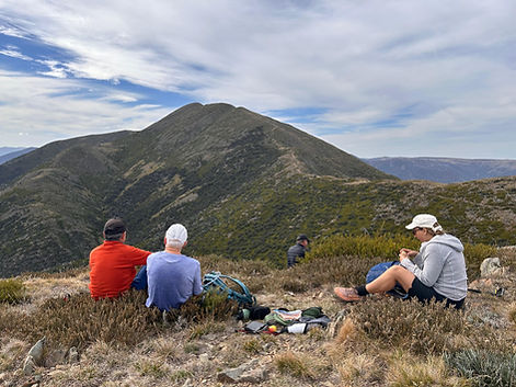
This is a definite bucket list hike that will take most of a full day to summit Victoria's second highest peak at 1,922m. It has an elevation gain of 900 metres along razorback ridge but the gradient is mostly moderate until the last ascend to the summit which is steep and rocky.
The trail head is across the road from Diamantina Hut, and as the name suggests, you walk on or near the top ridges of the alpine country through low shrubs and snow gum woodlands before reaching the rocky bluffs. Every hundred or so metres of elevation gain the vegetation changes until finally you summit well above the tree line with excellent views over the Bogong High Plains. The track is very worn out with jagged rocks sticky out so expect to stumble every now and then if your eyes are fixed on scenery instead of the path!
If you go in spring there may still be snow on the ground. It is mostly exposed with no shade so bring a hat and sunscreen and be prepared for quickly changing weather. Walkers can choose to overnight at Federation Hut near Little Feathertop to break up the distance across days or wait out bad weather.
Instagram REEL:
https://www.instagram.com/reel/DI0OnVHyxQN/

Trip Tips
-
There is no car park at the Diamantina Hut trail head. You would need to park on the narrow road shoulder, preferably on the uphill side as the shoulder on the other side is even narrower.
-
As this is a very popular trail, its best to start early so you do not have to park too far from the trail head. After the long arduous hike on the Razorback track, that little hill along the road walking back to your car can feel like another arduous hill to climb!
-
Even if you are there early, you will still find cars already parked by hikers who are camping over night at Federation Hut.
-
You can find accommodation at either Hotham heights or Dinner Plain, although I prefer the latter as there is more sprawling grounds for a little walk in the early morning or after dinner.
-
A good spot for good quality menu is at Elements in the Club Wyndham. For pub fair and a more rowdy atmosphere, there is the High Plains Hotel.
-
A good spot for rest and refreshment not far from the trail head after the hike is "The General" at Hotham Heights.
Hiking Tips
-
https://www.alltrails.com/trail/australia/victoria/mount-feathertop-via-the-razorback
-
The trail head is just across the Great Alpine Road from Diamantina Hut.
-
Quite soon from the start you approach the first big knoll. There are the options to go up and over which ups the puff factor right from the start, or go around on the narrow track on the right. The latter track is narrow and at a couple of points a little bit hairy for those afraid of heights but in reality not dangerous as its not aa sheer drop but with steepish slopes that are covered in bushes and shrub.
-
Most hikers take the 10km hike out and camp overnight before taking on the ascent up to the Mt Feathertop summit the next morning. As it would be a bit much for many average hikers to take on the 23-kilometre out and back hike to include the very steep climb up the summit.
-
We did the 21-kilometre out and back trek to Little Feathertop and Federation Hut as not all members of our group was prepared to go the whole hog on the same day. To do that you would need to allow 8 to 9 hours including dwell time to admire the panoramic scenery and taking photos!
-
A must-do epic hike!
Port Campbell
National Park
Port Campbell, Victoria
Port Campbell National Park is probably my clear favourite coastal walk in Victoria. The absolutely stunning coastal scape has one amazing lookout after another throughout the short 7-kilometre out and back trail.
Located on the Great Ocean Road, 3 hours' drive from Melbourne, I would rank this area miles ahead of the over-rated (in my opinion) Twelve Apostles.
The trail is mostly flat with a few short gentle hills, but is stacked with spectacular vistas of ocean cliff formations.
Instagram REEL:


Trip Tips
-
The quickest way to drive to Port Campbell National Park in via the inland route passing through Colac and Simpson. However, the more scenic route is on The Great Ocean Road, taking you through Geelong Torque, Lorne, and Apollo Bay. This could add one to two hour to your journey as there are so many scenic spots on the route where you are compelled to make photo stops. Probably best to plan enough time to go out one way and return via the other.
-
If you want to enjoy the vistas in peace and quiet, best to arrive early like before 9am before the day tripper and tourist buses get there. Or, go in the evening and catch the sunset.
-
For staying over night, best is top stay at nearby Port Campbell. Its a sleepy little town, but the happening spot for dinner and drinks is definitely the Port Campbell Hotel.
-
As of April 2025, the track to Thunder Cave and broken Head is closed for some park construction work. Do check before going.
Hiking Tips
-
https://www.alltrails.com/trail/australia/victoria/port-campbell-viewpoints-and-lookouts
-
To start the loop, best to drive to the main car park where the trail branches out to The Razorback and the Loch Ard Wreck Lookout.
-
Keep going Westward and take each side track to the lookout points for Loch Ard Gorge, Mutton Bird Lookout, Thunder Cave and Broken Head. The final branch out takes you to a lookout over the Sherbrook Estuary which offers a view to a lovely beach, offering a contrasting vista to the very rugged ocean cliff formations.
-
Information signs at each lookout has interesting information about the shipwreck and amazing stories of survival and rescue. Do visit also the small cemetery for more history.
-
Allow about 3 hours for the walk but dwell time at each captivating lookout.
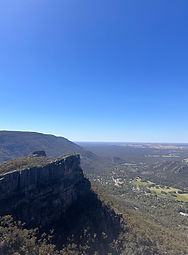
The Pinnacles via
Grand Canyon
The Grampians, Victoria
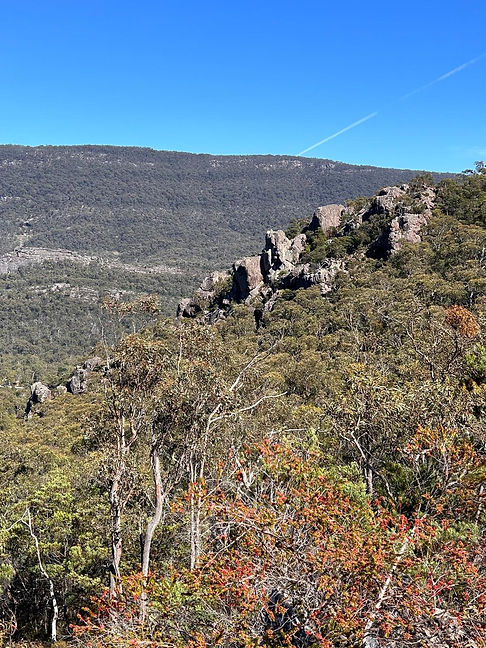
This 4-km out-and-back trail is probably the most visited in The Grampians National Park in Victoria. Cconsidered a moderately challenging route, it takes about 2 hours to complete.
This is an outstanding hike to the Pinnacle via some of the area's other must-see attractions. It has some lovely views and beautiful rock formations along the way. Starting from the Wonderland Road carpark, the path takes you through the incredible rocky gorge and Grand Canyon. It then continues by a long and low cavern called Cool Chamber. From there, the route takes you to Silent Street and a high-walled and narrow gorge.
Scampering up the rocky last bit of climb up to The Pinnacles, you will get panoramic views of Grampians National Park and Lake Bellfield.

Trip Tips
-
On weekends, the Wonderland Car Park where the trail head is fills up very quickly and people park on both sides if the narrow access road, making it quite tricky to get in and out. Do enjoy doing this hike, you would just need to be patient regarding access in and out and contribute to making it easier for everyone.
-
There is another route to The Pinnacles by driving further up Silverband Road to the Sundial Car Park. This loop route takes you also to the breath-taking Lake Lookout, but not through the Grand Canyon.
-
For a post-hike lunch with good menu and good service, my go-to spot is Livefast Cafe in Halls Gap.
-
For great a dinner menu, my favourite is Flame Brothers - but on weekends, definitely make advanced reservations or miss out.
Hiking Tips
-
https://www.alltrails.com/trail/australia/victoria/the-pinnacle-via-grand-canyon-cool-chamber-and-silent-street
-
Hiking through the Grand Canyon is a lovely experience that you need to do at least once in your life. Just be prepared for crowds as this is the most popular trail with serious hikers as well as tourists.
-
The hike from the Grand Canyon up to the Pinnacles can be steep and slippery in parts, and a bit tricky coming down for those not used to mountain hikes.
-
People have been known to have stepped off the sheer cliffs trying to take that ultimate selfie.
-
Another bucket list hike that must be ticked.
Boronia Peak
The Grampians, Victoria
Having done the Grand Canyon - Pinnacles hike three times, in my trip with my daughter to The Grampians in the Spring of 2024, we wanted to do a less trodden trail, and Boronia Peak was a great alternative.
This 8-km out-and-back trail starting from The Brambuk Cultural Centre, took us to an amazing rocky peak that gave us panoramic views on the opposite side of Halls Gap from the Pinnacles.
After a flat-ish walk along Fyans Creek, the track starts a constant climb that leads up to a ridge studded with rocky outcrops and rock walls. At the top, you need to scramble over a rocky top that is a bit technical and could be daunting if you are not comfortable with heights or climbing over boulders.
The rocky summit offers a 360-degree vista of the Grampians Ranges, Cathedral Range, Mount Williams Range on one side, endless flat plains, Fyans Valley, Fyans Creek, and Fyans Lake on the other.
This is one of the Grampians best walks but is less crowded than some of the other hikes in the region.

Trip Tips
-
There is ample parking at the Brambuk Cultural Centre. The cultural centre itself is definitely worth spending time in after your hike.
-
For a post-hike lunch with good menu and good service, my go-to spot is Livefast Cafe in Halls Gap.
-
For great a dinner menu, my favourite is Flame Brothers - but on weekends, definitely make advanced reservations or miss out.
Hiking Tips
-
https://www.alltrails.com/trail/australia/victoria/boronia-peak
-
A perfect hike in the Grampians that is not crowded so you can enjoy some quiet time in nature and have some solitude with your group at the rocky peak, enjoying the vistas without the noise.
-
Be prepared to a bit of technical boulder scrambling up and down.
Chatauqua Peak
The Grampians, Victoria
The Chatauqua Peak loop is a delightful loop that offers a variety of terrain plus spectacular views across the Grampians National Park. The loop also takes in Clematis Falls, with a side jaunt at the bottom to Venus Baths which is a popular swimming hole in the Summer.
The trail starts at the town of Halls Gap. We recommend doing it counter-clockwise so you make a gradual climb with increasingly better vistas. The side arm out and back that takes you to the top of Chatauqua Peak is a challenging rock scramble. Some agility and fitness is required to clamber up and tricky to come down. The top ridge is narrow and fairly exposed, hence caution is to be exercised if it is wet or windy. It is not for everyone, especially those who are afraid of heights or exposed climbs.
The trek down is over lovely bush land. Coming down the last steps to a T junction at the bottom, hang a right to head out to Venus Baths to take a dip in the pools before completing the hike back to Halls Gap. Usually there are lots of kangaroos hanging out near the camp grounds.
Instagram REEL:
Trip Tips
-
There is a large car park in Halls Gap across the road from The General Store but fills up quickly on weekends. Overflow parking could be found on School Road where there is a camp site.
-
Best to find accommodation in Halls Gap or within walking distance so you do not need to find parking to do this hike or for dinner.
-
For a post-hike lunch with good menu and good service, my go-to spot is Livefast Cafe in Halls Gap.
-
For great a dinner menu, my favourite is Flame Brothers - but on weekends, definitely make advanced reservations or miss out.
Hiking Tips
-
https://www.alltrails.com/trail/australia/victoria/chatauqua-peak-loop
-
Starting from the main car park at Halls Gap, make your way past the camp site on School Road to the main trail head near the start of Mt Victory Road.
-
It is recommended to do the loop counter-clockwise to tale on most of the climb at the start and be rewarded with amazing views as you ascend.
-
Be prepared to a quite technical boulder scrambling up and down at the summit - which may not be suitable for everyone.
-
Descending down to Stony Creek, hang a right for about 300 metres to get to Venus Baths which is very popular for a cooling dip on a warm day.
Zumstein to Fish Falls & Mackenzie Falls
The Grampains, Victoria
This 8-kilometre out-and-back trail near Zumsteins is a very soulful walk in contrast to other arduous mountainous hikes in The Grampians. It is a moderately challenging with an elevation gain of 180 metres, including a series of heart pumping stairs.
The hike takes you to two beautiful waterfalls and a few smaller cascades. The path starts from the parking area at Zumstein Picnic Area on Mount Victory Road, where there are public toilets, picnic tables, and BBQs.
The wonderful trek along the Mackenzie River is very picturesque offering endless photo opportunities.

Trip Tips
-
Zumstein Picnic area is about a 30-minute drive from Halls Gap - a popular area to stay when visiting the Grampians as its where the cafes and restaurants are concentrated.
-
There is the alternative of starting the out and back hike from the Mackenzie Falls car park which is 5 minutes' drive closer to Halls Gap, but there is a long series of steps leading from there down to Mackenzie Falls which you would need to climb back up at the end of the hike.
-
On the way back top Halls Gap, take a stop at Reeds Lookout for a lovely vista, and if you have time, take the 1-kilometre walk out to The Balconies.
Hiking Tips
-
https://www.alltrails.com/trail/australia/victoria/mackenzie-river-walk-from-zumstein-picnic-area
-
My daughter and I thoroughly enjoyed this mesmerising hike as a very zenful change to the other strenuous hikes in the Grampians.
-
The two falls were in beautiful full flow which they usually are in Spring unless there has been a period of dry weather.
-
The river itself was magical to walk along, surrounded by a rocky canyon, lush green and spring flowers.
Estate Spur Loop
Lake Eildon, Victoria
The awesome hike at Lake Eildon National Park in the Central Highlands is totally worth the 2+ hours drive from Melbourne.
This 9-kilometre loop has an elevation gain of 480 metres. The loop starts with the constant climb up Estate Spur, as the view gets better with every step, of the sprawling Lake Eildon.
This is followed by the descent down on Bedrock Creek Track back down to the lake's edge to Pint Mibus and Point Mead.
Instagram REEL:
https://www.instagram.com/p/DEJWwkByO-9/


Trip Tips
-
The trail head starts at Lakeside Campground on Lakeside Road.
-
There are many fantastic hikes at Lake Eildon National Park and this is one of them!
-
For a coffee and refreshment break after the hike, check out Elli & Ivy cafe in Alexandra, but check closing times.
Hiking Tips
-
https://www.alltrails.com/trail/australia/victoria/point-mibus-and-point-mead-via-estate-spur-track
-
Strongly recommend to do the loop counter-clockwise, starting with the climb up Estate Spur. This climb and the views from this hill are the highlights of the hike. Do take your time to enjoy the sprawling views of the lake and even plan a little picnic from one of many vista points on this hill.
-
There are a couple of false peaks that makes you think you have reached the end of the climb, only to see another hill after, but with the ever improving views, you will soon accept the illusions.
-
The hike down on Bedrock Creek Track is a welcome relief after the climb but watch out not to trip over fallen trees and large roots.
-
At the bottom of the descent, the trail is not clearly marked for the next 200 metres or so. There is also some scrambling required over fallen trees and overgrown areas. You won't get lost if you follow the contour of the lake's edge the rest of the way to get back to parking.
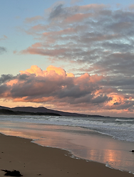
Betka to Secret Beach
Mallacoota, VIC
A beautiful Autumn day at Mallacoota for a coastal walk from Betka Beach to Secret Beach. Surprisingly, there were few people on this amazing trail, making the walk even more special.
Known for its stunning coastal views and beautiful sunsets, a visit to Mallacoota is not complete without a walk at dusk on this trail.
Instagram REEL:

Trip Tips
-
The trail head starts at Lakeside Campground on Lakeside Road.
-
There are many fantastic hikes at Lake Eildon National Park and this is one of them!
-
For a coffee and refreshment break after the hike, check out Elli & Ivy cafe in Alexandra, but check closing times.
Mount Buffalo
Porepunkah, Victoria
Our trip to Mt Buffalo was delayed by two days as we waited to let the bushfires at Walwa and Alpine National Park come under control. Still, we cramped almost everything into 1.5 days, exploring in awe the absolutely stunning boulder formations - The Horn, Cathedral Peak, The Hump, Sentinel, The Castle, Corral Peak, The Gorge, The Monolith, The Galleries, Dicksons Falls, crawling through Mohamet’s Tomb and finishing with a dip in the swimming hole at Rollasons Falls.
Instagram REEL:
https://www.instagram.com/p/DUAAofFAePe/
Trip Tips
-
Mount Buffalo National Park is a stunning hiking destination defined by its multitude of amazing large rocky formations.
-
There are beautiful trails and waterfalls to warrant staying several days in the area. To fully immerse in the park, the best option is to camp at the Lake Catani Camp Ground. If camping is no longer your thing, the closest accommodation is found in Porepunkah or Bright from where you can make day trips up the mountain to access the trails.


Hiking Tips
-
There is a lot of hype about the 'Big Hike' where you start at the bottom of the mountain and hike up to Gorge Day Visitor Area. This is a strenuous long hike that has little reward until you get to The Gorge and the multiple lookouts at the top.
-
You are better off driving up to the Visitor Area of various trail heads further up Mt Buffalo Road and go on the various day-hikes in the area, taking in the many stunning locations mentioned in our hike experience.
-
The Mt Buffalo Chalet had been closed for several years. It was being renovated through 2025 and is slated to re-open in 2026 with possibly accommodation and a restaurant.